


The Manaslu Circuit Trek map, which is 14 days old, includes updated, detailed trail information and interactive features. For trekking in restricted areas, including the Manaslu Circuit, a detailed map is essential; we have provided the Manaslu Circuit trek route map to enhance the trekking experience.
The map includes essential elements: trails, routes, landmarks, elevation, and zoom-in and zoom-out controls. Other notable features include a Legend and Itinerary highlights. Because the map uses various signs and symbols with different shapes and colors, the Legend is an invaluable feature that makes the map easier to interpret.
Symbols with different colors and shapes for the main hiking trail, secondary route, driving route, viewpoint, mountain, lake, suspension bridge, pass, monastery, glacier, and checkpost are visible on the map. Trekkers found it a little tricky to navigate without knowing the description of each symbol, thus, the Legend plays a crucial role in such cases.
Moreover, the itinerary highlighted below the Legend is another essential feature map. By reviewing the Itinerary highlights, trekkers know their day-to-day destinations. As per the highlighted itinerary, the Manaslu Circuit is a 15-day itinerary, including the first and fifteenth days in Kathmandu and the second day for Kathmandu sightseeing.
Brief Itinerary of Manaslu Circuit Trek Map
As shown on the itinerary highlighted on the map, your first day is in Kathmandu Valley. The second day involves sightseeing around the Kathmandu Valley. Day 2 allows you to prepare for the journey in the Manaslu area. On day three, the Manaslu Circuit trip begins. However, as seen on the map, trekkers don't need to trek that day. Instead, trekkers are driven to Soti Khola by bus or jeep.
As shown on the map, the Manaslu Circuit trek begins with a hike from Soti Khola to Macchakhola. Likewise, the fifth day is a trek to Jagat, and the sixth is Philim. The Manaslu Circuit route map indicates a dotted line above Philim, representing the secondary route. However, you'll take the main hiking route to continue the Manaslu circuit trek.
On the seventh day, the journey moves from Philim towards Deng. Trekkers reach Namrung in eight days, as highlighted in the itinerary. Similarly, day 9 takes you to Samagaon via Lho gaon. As shown on the map, there is a monastery symbol in Samagaon, which you'll visit on the tenth day of acclimatization. Furthermore, on the acclimatization day in Samagaon, trekkers hike to Manalsu Base Camp.
Day 11 takes you to Samdo and, on the twelfth day, to Dharmashala. Day thirteen takes you to Bhimthang, and you can see the national flag of Nepal between Dharmashala and Bhimthang, marking the pass. Thus, trekkers need to cross the longest Himalayan pass, the Larkya La, on the thirteenth day, making the journey one of the most adventurous.
From day 13, the journey continues, descending to Dharapani on the fourteenth day, then a jeep ride to Kathmandu on the fifteenth day.
Mountain views during the Manaslu Trekking
The Manaslu Circuit route map quickly identifies mountain peaks. The mountains shown on the map include Mount Manaslu (8163m), Ngadichuli (7893m), Shringi Himal (7187m), Himal Chuli (7193m), and Manaslu North (7157m). Hence, trekkers can enjoy the view of all the mountain peaks depicted on the map. However, trekkers see several unnamed peaks along the Manaslu Circuit trek.
Elevation of the Manaslu Base Camp
The map highlights key areas of the Manaslu region to help trekkers gauge the elevation gain. As shown on the map, the trip begins from an elevation of 1400m at Kathmandu. Then, elevation declined to 730m at Soti Khola, indicating a loss of elevation. As trekkers move above Soti Khola, they'll start to gain elevation, bypassing the villages of Macchakhola at 890m, Jagat at 1400m, and Philim at 1700m. Deng at 2059, Nmarung at 2957m, Samagoan at 3530m, Manaslu Base Camp at 4800 meters, Samdo at 3875m, and Dharmashala at 4480m.
After Dharmashala, trekkers cross the highest pass at 5160m and descend, resulting in a loss of elevation. Trekkers descend through Bhimthang at 3720m and Dharapani at 1860m. We are in the Annapurna Conservation Area, and we drive to Kathmandu at 1400m.
Manaslu Mountain in Map of Nepal: A Guide to the 8th Highest Peak
Manaslu, also known as "The Mountain of the Spirit," is located in the Manaslu Himal range of the Nepalese Himalayas. Standing tall at 8,163 meters (26,781 feet), Manaslu Mountain in Nepal lies northeast of Kathmandu and west of the Annapurna range.
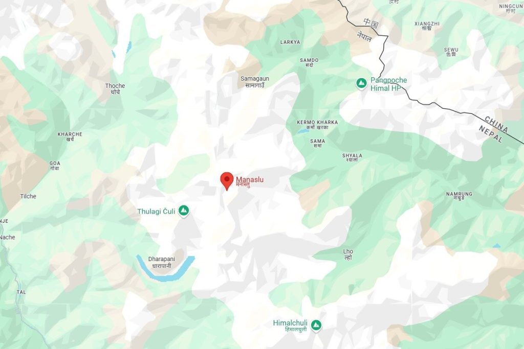
If you look at a map of Nepal, you'll find that Manaslu sits in the Gorkha District, part of the Gandaki Province. It is a pristine region surrounded by diverse landscapes, from lush forests to snow-clad peaks. The Manaslu Circuit Trek Map highlights this area as a popular trekking destination for those seeking adventure away from the crowds.
Mount Manaslu in the Map of Nepal: How to Locate It
Finding Mount Manaslu on the map of Nepal is easy if you know what to look for. Here's a quick breakdown:
- Coordinates: The mountain is located at approximately 28.5497° N latitude and 84.5597° E longitude.
- Proximity: Manaslu lies about 100 kilometers northwest of Kathmandu, making it accessible via road to Arughat, the starting point for the trek.
- Surrounding Landmarks: It lies west of Langtang and east of the Annapurna region, connecting to popular trekking routes, including the Annapurna Circuit.
When exploring Manaslu on a map of Nepal, you'll notice that the area is within the Manaslu Conservation Area, a protected conservation zone that safeguards its unique biodiversity and ecosystems.
Manaslu Mountain in the Map of Nepal with Distance
Explore the beauty of Manaslu—find it on the map, plan your trek, and let the adventure begin.
Understanding the distance is essential for planning your trek. Here's how Manaslu Mountain in the map of Nepal translates into practical travel:
- From Kathmandu: The trek's starting point, Arughat, is about 125 kilometers away and takes approximately 6–8 hours by road.
- From Pokhara, the distance to Arughat or Soti Khola is roughly 165 kilometers, the second key starting point for the trek.
- Trekking Distance: The Manaslu Circuit Trek itself spans around 170 kilometers (105 miles) and takes 14–16 days to complete.
The circuit encircles the mountain, offering awe-inspiring views of Manaslu and surrounding peaks, making it a perfect choice for adventure seekers.
Where is Manaslu located on the map of Nepal?
If you've been wondering, "Where is Manaslu located on the map of Nepal?", here's the answer:
Manaslu is located in the northern part of Nepal, in the Mansri Himalayan range of the Gorkha District. It's a part of the Himalayan mountain range and dominates the region with its towering height and dramatic ridges.
When locating Manaslu on a map of Nepal, you'll notice it's near several key villages along the circuit trek, such as Samagaun, Dharamsala, and Jagat. These points serve as rest stops where trekkers can soak in the culture, hospitality, and breathtaking views of the Himalayas.
Explore Manaslu Mountain on Google Maps
Planning your trek? Here is Manaslu Mountain on the Google Maps map of Nepal for proper navigation and route details. In fact, on Google Maps, the starting point, villages, and other major points along the Manaslu Trek are easy to identify.