


If there’s one mountain that captures the heart of everyone who lays eyes on it, it’s Ama Dablam. Standing proudly in the Khumbu region of eastern Nepal, this peak is often referred to as the “Matterhorn of the Himalayas” — and for good reason. Its sharp ridges and pointed summit create a picture-perfect pyramid, making it one of the most photographed mountains in the world.
But this mountain isn’t just about looks. Ama Dablam is deeply respected by both local Sherpas and global adventurers. Its name, which means “Mother’s Necklace,” refers to the long ridges (the mother’s arms) and the hanging glacier (the dablam, or pendant). This spiritual and cultural symbolism adds even more meaning to its already magnetic presence.
Highlights of Mount Ama Dablam
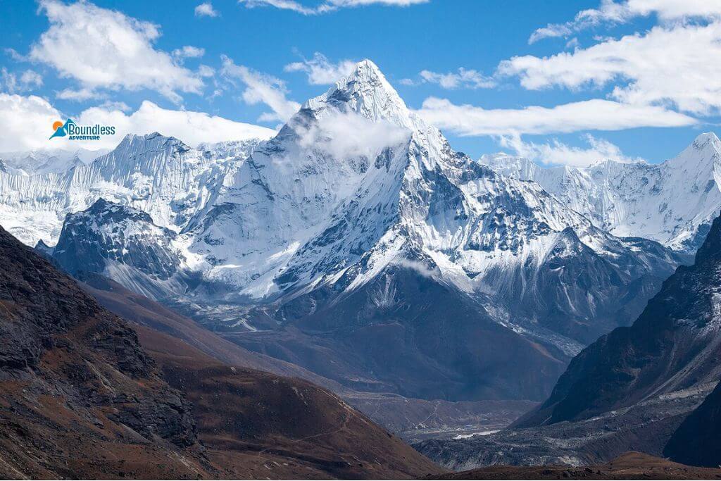
- Iconic Pyramid Shape: Known for its stunning, sharp ridges and a hanging glacier called the “dablam,” this peak is often called one of the most beautiful mountains in the world.
- Technical but Accessible Climb: Offers challenging routes involving rock, ice, and mixed terrain, ideal for climbers looking for serious yet achievable alpine adventure.
- Perfect Location on the Everest Trail: Visible from popular trekking spots like Namche, Tengboche, and Dingboche, it often steals the spotlight from Everest in photos.
- Scenic and Quiet Base Camp: The Ama Dablam base camp provides peaceful surroundings at 4,600 meters, with beautiful views of nearby peaks like Lhotse and Kangtega.
- Cultural and Spiritual Significance: The mountain symbolizes a mother’s necklace in Sherpa culture, making it a sacred and emotionally meaningful peak.
- Photographer’s Paradise: Its dramatic shape and clear skies during trekking seasons make it one of the most photographed mountains in Nepal.
Where is the Ama Dablam Located?
Ama Dablam is located in eastern Nepal of Koshi Province, within the renowned Khumbu region (Eastern Himalayas range) — the same area that’s home to Mount Everest. It sits inside Sagarmatha National Park, a UNESCO World Heritage Site known for its dramatic Himalayan scenery and deep-rooted Sherpa culture.
Geographically, the mountain lies at approximately 27.8615° N latitude and 86.8619° E longitude, near the villages of Pangboche and Dingboche. It stands just south of Everest and Lhotse, placing it among some of the most iconic peaks in the region. Part of the Mahalangur Himal range, it is a central and highly visible highlight for trekkers and climbers exploring the Everest region.
Its main summit reaches a height of 6,812 meters (22,349 feet), making it one of the most striking and photogenic peaks in the Himalayas. Thanks to its prominent location, it is visible from many classic trekking routes, offering unforgettable views along the journey.
What Is the History of Ama Dablam?
In 1961, the Ama Dablam was first climbed successfully by the team that was made up of Barry Bishop, Mike Ward, Wally Romanes and Mike Gill. This ascent was as part of the Silver Hut expedition that was sponsored by Sir Edmund Hillary who remains as one of the renowned mountaineers of all time. They had also reached the summit which meant that this was a big accomplishment since AmaDablam is a very beautiful mountain, and there is also a technical challenge in that, there were steep sections of rocks and ice.
Before this successful climb, the mountain had long been known to local Sherpa communities who regarded it as sacred. The name Ama Dablam translates to “Mother’s Necklace” in the Sherpa language, referring to the long ridges that resemble a mother’s arms and the hanging glacier that looks like a traditional pendant. The mountain is often featured in Sherpa religious culture, appearing in monasteries, prayer flags, and local art throughout the Khumbu region.
For climbers, AmaDablam remains a respected peak due to its combination of stunning appearance and climbing challenges. Its history reflects both the spirit of Himalayan mountaineering and the deep cultural significance it holds for the people who live in its shadow.
Also learn about Khumbu Glacier – Discover Everything You Need to Know
What Is the Height of Ama Dablam?
The Ama Dablam height is 6,812 meters (22,349 feet) above sea level. While not one of the tallest peaks in the Himalayas, it stands out due to its striking shape and technical nature.
Its elevation is ideal for climbers looking for high-altitude experience without venturing into the extreme death zone found on peaks above 8,000 meters. This makes it a valuable stepping stone for mountaineers aiming to climb Everest or Lhotse.
What Kind of Landscape and Terrain Can You Expect Around Ama Dablam?
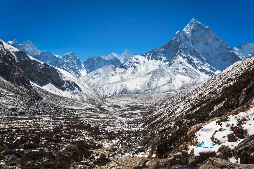
The landscape around Amadablam is a stunning mix of lush forests, alpine meadows, and traditional Sherpa villages. You’ll walk through rhododendron and pine forests, cross hanging bridges, and enjoy sweeping views of snow-capped peaks as you ascend.
The terrain becomes more rugged near the mountain. Expect rocky paths, steep moraines, and icy ridgelines. For climbers, the route includes technical sections with rock, ice, and snow, making it both demanding and deeply rewarding.
Landscape Around Ama Dablam
The landscape surrounding Ama Dablam is nothing short of spectacular. From the moment you begin the approach trek, you’ll find yourself immersed in a world of natural beauty — dense rhododendron and pine forests, crystal-clear rivers, and traditional Sherpa villages that seem frozen in time. Along the trail, suspension bridges flutter with colorful prayer flags, and mani stones carved with Buddhist mantras line the path, creating a spiritually rich atmosphere.
As you gain elevation. The scenery opens up to vast alpine meadows and sweeping views of snow-capped giants in every direction. The mountain itself dominates the skyline, with its sharp peak rising like a sentinel over the Khumbu Valley.
Terrain Around Ama Dablam
The terrain around Ama-Dablam becomes progressively more challenging as you move higher. Lower elevations feature well-defined trails through forest and pastureland. But as you approach the mountain, the terrain shifts dramatically — you’ll cross rocky moraines, navigate loose scree paths, and eventually walk alongside glacial ice and exposed ridgelines.
For climbers, Ama-Dablam isn’t just steep — it’s seriously technical. You’ll face rock walls, icy sections, and narrow ledges where every step counts. Glaciers carve deep into its sides, and the ridgelines stretch toward neighboring peaks like Taboche and Kangtega, making the whole landscape feel wild, remote, and incredibly alive.
Whether you’re trekking to the base or attempting a summit, the combination of landscape and terrain around Ama Dablam offers one of the most visually and physically rewarding experiences in the Himalayas.
How Can You Reach Ama Dablam from Kathmandu?
Reaching Ama Dablam from Kathmandu is an adventure in itself — one that takes you from the busy capital city to the peaceful heart of the Himalayas. While the journey may seem remote. It’s surprisingly accessible with the proper planning.
Step 1: Fly from Kathmandu to Lukla
Your journey begins with a short but unforgettable flight from Kathmandu to Lukla. The flight takes about 30–35 minutes and offers jaw-dropping aerial views of the Himalayan range. It’s a breathtaking way to start your adventure, with mountains so close it feels like you could almost touch them. Lukla Airport, also known as Tenzing-Hillary Airport, is often called one of the most thrilling airstrips in the world due to its short runway and dramatic mountain surroundings.
Once you land in Lukla, the vibe changes instantly — from city hustle to mountain calm. This is where your trek officially starts.
Step 2: Trek from Lukla to Namche Bazaar
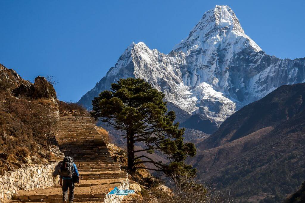
From Lukla, you’ll start trekking through charming villages like Phakding and Monjo, passing over suspension bridges and along the Dudh Koshi River. After a couple of days of gradual climbing, you’ll reach Namche Bazaar, the bustling Sherpa capital at 3,440 meters. It’s the main hub for trekkers heading to Everest and Ama-Dablam, with shops, bakeries, and great acclimatization hikes.
Recommendation Read: Top 10 Things to Do in Namche Bazaar
Step 3: Trek from Namche to Pangboche via Tengboche
From Namche, the trail continues towards Tengboche Monastery, one of the most scenic and spiritual spots in the region. On a clear day, you’ll get your first unobstructed view of Ama-Dablam, standing tall and graceful in the distance — and believe me, it’s a moment you won’t forget.
After visiting the monastery, you’ll descend and then gently climb to Pangboche, the nearest village to the mountain. This is where most climbers and trekkers rest before heading to the base.
Step 4: Reach Ama Dablam Base Camp
From Pangboche, it’s a short 2–3 hour hike to Ama Dablam base camp, located at around 4,600 meters. The trail is less crowded here, and the scenery becomes even more dramatic. You’ll pass yak pastures, cross small streams, and eventually arrive at a peaceful, open plateau right below the towering peak.
In summary, the trek from Lukla to base camp typically takes 5 to 7 days, depending on your pace and acclimatization needs. Whether you’re aiming to climb or just witness the mountain up close, the journey is filled with moments that stay with you long after you’ve left the trail.
What Is the Weather and Temperature on Ama Dablam?
Weather conditions around Ama-Dablam can change quickly, especially at high elevations. Winters are cold and dry, while summers bring monsoon moisture and limited visibility. Spring and autumn offer the most stable and clear conditions.
Ama Dablam Weather and Temperature by Month
| Month | Temperature (°C) | Weather Conditions |
| Jan | -15 to -5 | Very cold, dry, clear skies |
| Feb | -12 to 0 | Cold, clear, windy |
| Mar | -10 to 2 | Dry, improving conditions |
| Apr | -5 to 5 | Stable, warmer, good visibility |
| May | 0 to 10 | Pleasant, risk of pre-monsoon rains |
| Jun | 2 to 12 | Humid, cloudy, monsoon starts |
| Jul | 5 to 15 | Monsoon peak, wet, poor views |
| Aug | 5 to 15 | Continued rain, slippery trails |
| Sep | 2 to 10 | Drying, clear skies return |
| Oct | -5 to 5 | Crisp, dry, ideal conditions |
| Nov | -10 to 0 | Cold, excellent visibility |
| Dec | -15 to -5 | Very cold, snow possible |
When Is the Best Time to Climb Ama Dablam?
The best time to attempt climbing Ama Dablam is during the pre-monsoon (April–May) and post-monsoon (late September to November) seasons. These months offer clear skies, moderate temperatures, and more predictable weather.
Autumn is especially popular because of its excellent visibility, stable conditions, and fewer weather-related disruptions. Spring, on the other hand, offers blooming rhododendrons and less-crowded trails.
Also, if you want to learn about best time for visiting Nepal. Read our blog on best time to visit Nepal.
What Are the Main Routes and Camps Used While Climbing Ama Dablam?
Most climbers use the standard Southwest Ridge route. Which is well-established and supported with fixed ropes in key sections. The ascent typically involves three camps:
- Camp I (5,700m): Set up above a rocky ridge
- Camp II (5,900m): Narrow, exposed ledge
- Camp III (6,300m): Just below the summit pyramid
From Camp III, climbers make their final push to the summit, tackling icy slopes and steep, technical terrain along the way. It’s a tough climb, no doubt — but many say it’s one of the most beautiful and rewarding routes out there.
What Difficulties and Challenges Can You Face During the Ama Dablam Expedition?
Climbing Ama-Dablam is an incredible achievement — but it’s not easy. The mountain demands physical strength, mental resilience, and solid mountaineering skills. Whether you’re an experienced climber or someone working toward higher-altitude goals, it’s important to understand what lies ahead.
Difficulties
These are the technical and environmental obstacles that make the climb demanding:
Technical Climbing:
The standard route up Ama-Dablam is called the Southwest Ridge. It is a mix of climbing on rock, snow, and ice. You’ll find yourself using fixed ropes, tackling steep walls, and crossing exposed ridges that keep things interesting. Because of this, having some real experience with ropes, crampons, and mixed climbing is super important before you give it a go.
High Altitude:
With a summit of 6,812 meters. Ama Dablam is high enough to cause altitude-related problems. Even fit climbers can experience headaches, nausea, or fatigue. If they don’t acclimatize properly.
Weather Variability:
The weather can shift frequently. Climbers may face high winds, snowstorms, or whiteouts even in peak seasons. Storms at higher camps can delay summit pushes or force early descents.
Ice and Rock Fall Hazards:
Certain sections of the route, especially near Camp II and the Dablam (the hanging glacier), are known for rock and icefall. These are natural but unpredictable risks.
Challenges
These are the broader physical, mental, and logistical hurdles you’ll need to overcome:
Endurance and Physical Fitness:
Getting to base camp means a few days of trekking over some tough trails. Once you’re up on the mountain. You’ll be carrying your gear, climbing steep spots, and dealing with tiredness all the way. You really need to be in good shape and have plenty of stamina to make it through.
Mental Pressure and Focus:
The climb demands constant attention to safety, from clipping into ropes properly to staying balanced on narrow ridges. Mental fatigue can lead to dangerous mistakes.
Cold Temperatures:
Nights at higher camps are bitterly cold, often dropping below -15°C. Keeping warm, especially during summit attempts that start before dawn, is a serious challenge.
Limited Support at High Camps:
Compared to Everest, Ama-Dablam has fewer infrastructure and rescue options. Once you’re above base camp. You rely heavily on your guides, team, and personal preparation.
Permit and Climbing Regulations:
Trekkers require permits for Ama Dablam. You must climb with a registered agency. Delays in logistics, paperwork, or gear transport can test your patience and planning skills. (Note: Everest Trek Permit)
Why Is Ama Dablam So Famous Among Climbers and Trekkers?
Ama Dablam is a bucket-list mountain — not just because it’s beautiful, but because it offers an incredibly rewarding experience for climbers and trekkers alike. Unlike Everest, it doesn’t attract large commercial crowds, which means the experience feels more personal and pure.
The peak has gained fame for its technical routes. The route demands terrain and relatively accessible height. That makes it a favorite training ground for climbers preparing for higher altitudes. It’s also visible from many points along the Everest Base Camp trek, where trekkers stop to admire its stunning form rising out of the valley.
How Safe Is the Ama Dablam Expedition for Trekkers and Climbers?
With the right preparation, gear, and support team, Ama Dablam is considered a safe but serious climb. Choosing a reputable guide company, properly acclimatizing, and being aware of weather forecasts are crucial safety measures.
Trekking to the base camp is pretty safe and doable, even if you’re not planning to climb to the top. The path is easy to follow, and you’ll find plenty of villages along the way with cozy lodges and helpful services. It’s a great way to experience the area without the full climbing challenge.
Final Thoughts
Ama Dablam’s not just a mountain. It’s got this kind of quiet power and beauty that grabs you the second you see it. Sitting right in the middle of the Himalayas, it’s been drawing in people — climbers, trekkers, dreamers — for ages.
Whether you’re chilling at Tengboche Monastery looking up at it or actually trying to climb it, there’s no forgetting Ama Dablam. It stirs something inside you. If you’re after more than just ticking off another climb, this mountain gives you a deep connection to nature. And with Boundless Adventure, it’s not just a trip — it’s a real journey with folks who know their stuff and care about the experience. Maybe it’s time to stop thinking and just go. Your Ama Dablam adventure might be closer than you think.
Touch the sky. Stand beneath the sacred face of Ama Dablam with Boundless Adventure.
FAQs
Where is Ama Dablam located?
Ama Dablam is located in the Khumbu region of eastern Nepal. It is not far from Mount Everest. You’ll first catch sight of it on the Everest Base Camp trail, especially near Tengboche. Its name means “Mother’s Necklace,” and it’s just as beautiful and graceful as it sounds.
How difficult is it to climb Ama Dablam?
Climbing Ama Dablam is technically challenging and requires solid mountaineering experience. It’s not just about fitness — you need to be confident with ropes, ice axes, and steep terrain. For many, summiting Ama Dablam is a serious personal achievement, not just another tick on a list.
What is the best time to climb Ama Dablam?
The best time to climb Ama Dablam is during the pre-monsoon (April–May) or post-monsoon (late September–November) seasons. These months offer clear skies, stable weather, and stunning views. Avoid winter and the monsoon period, as conditions become harsh and risky.
Do I need prior climbing experience for Ama Dablam?
Yes, climbing Ama Dablam isn’t for beginners — you’ll need real mountaineering experience. It involves exposed ridges, fixed ropes, and ice climbing skills. If you’ve successfully climbed peaks like Island Peak or Lobuche East, you’re heading in the right direction.
How high is Ama Dablam?
Ama Dablam stands tall at 6,812 meters (22,349 feet) above sea level. While it’s not Nepal’s tallest peak, its iconic shape makes it one of the most recognizable. Many say Ama Dablam is the most beautiful mountain they’ve ever seen — and they’re not wrong.
Can I see Ama Dablam without climbing it?
Absolutely — you don’t need to be a climber to enjoy the magic of Ama Dablam. It’s visible from several spots along the Everest Base Camp trail, especially from Tengboche and Pangboche. For many trekkers, just standing in its shadow is a dream come true.
Why is Ama Dablam so famous?
Ama Dablam is famous for its unique shape, which resembles a mother’s outstretched arms with a sacred pendant around her neck. It’s also known for being one of the most photogenic peaks in the Himalayas. Whether you’re a mountaineer or just a mountain lover, Ama Dablam captures hearts instantly.