


Mount K2, the second-highest mountain on Earth (Mount Everest), is the world’s second-highest Mountain. Stands as a remote and terrifying sentinel in the Karakoram Range. Unlike Mt. Everest, it remains as off-the-beaten-path far from popular trekking circuits, demanding effort even to glimpse its icy crown. Located on the border between Pakistan and China, K2 rises to a height of 8,611 meters (28,251 feet) above sea level. It dominates the skyline of Pakistan’s Gilgit-Baltistan region, surrounded by glaciers, deep valleys, and other towering peaks.
Often referred to as the “Savage Mountain,” K2 is notorious for its difficulty, danger, and dramatic weather. While many associate it with the Himalayas, it belongs to the rugged Karakoram Range. The mountain’s coordinates place it squarely in one of the most isolated and inhospitable regions on the planet. Reaching K2 requires an arduous journey through raw, untamed landscapes far from modern roads. Its unique geographical location adds to its mystique and isolation. Knowing where Mount K2 is means discovering one of Earth’s last true wilderness frontiers.
Where Exactly Is K2?
What does K2 mean? Mt. Godwin Austen: Another name is Mount K2
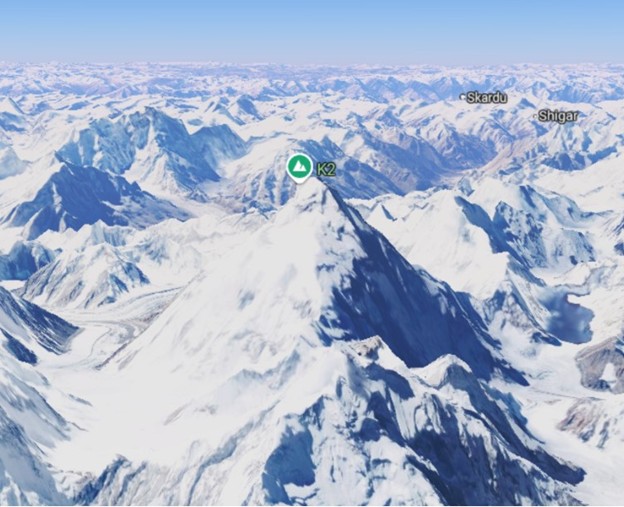
K2, the world’s second-highest mountain (8,611 m / 28,251 ft), lies in the Karakoram Range on the Pakistan-China border. It is part of Gilgit-Baltistan in Pakistan and Xinjiang in China, surrounded by glaciers and some of the world’s tallest peaks.
Karakoram Range itself is part of the vast, complex system of mountains stretching across South and Central Asia.
- Latitude and Longitude: Coordinates are approximately 35°52′57″N and 76°30′48″E.
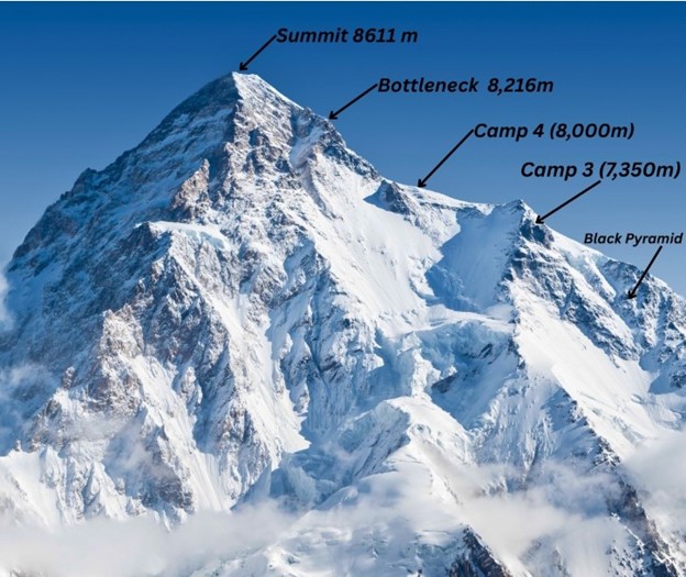
- Altitude: Standing tall at 8,611 meters (28,251 feet), K2 is the second-highest mountain on Earth, after Mount Everest.
- Borders: The peak lies near the northern boundary of Pakistan’s Gilgit-Baltistan region, formerly called the Northern Areas, and faces China’s Xinjiang Autonomous Region.
K2’s summit itself straddles the Sino-Pakistani border, though the standard climbing routes lie entirely within Pakistani territory.
wondering about the world’s highest mountain- Everest location? Visit the blog “Where is Mount Everest Located“.
Karakoram, Himalayas & Beyond
Many mistakenly believe K2 is in the Himalayas. Technically, it is not.
- Karakoram Range: K2 belongs to the Karakoram, an extraordinary range extending about 500 km (310 miles).
- Relation to the Himalayas: The Himalayas lie southeast of the Karakoram, separated by the Indus River. Though both ranges are part of the greater Himalayan organic system, K2 is distinctly Karakoram.
The Karakoram Range hosts other legendary giants: Broad Peak, Gasherbrum I and II, and Masherbrum, and it holds the greatest concentration of glaciers outside the Polar Regions.
The Name: Why “K2”?
“K2” is an unusual name among mountain giants: stark, technical, and almost cold.
- Origins: The name was given during the Great Trigonometrical Survey of British India in 1856. Thomas Montgomerie labeled the peaks of the Karakoram with “K” followed by numbers: K1, K2, K3, etc.
- Local names:
- Chogori: Believed to derive from Balti words “Chhogo Ri,” meaning “Big Mountain.”
- Dapsang: Another historical name, though less common.
Yet “K2” endured internationally because there was no widely accepted local name at the time of the survey.
How to Get There?
The remote location of K2 means it remains far from roads, cities, and even villages.
- Gateway City: Most expeditions begin in Islamabad, Pakistan’s capital.
- Further North: From Islamabad, travelers fly or drive to Skardu, the administrative capital of Baltistan. Skardu is an isolated town nestled among mountains and rivers.
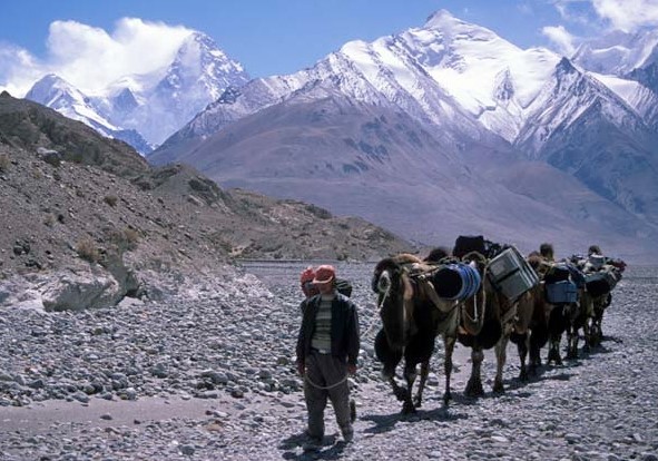
- The Trek: After Skardu, teams drive by jeep to Askole or Jhula, the last permanent settlements.
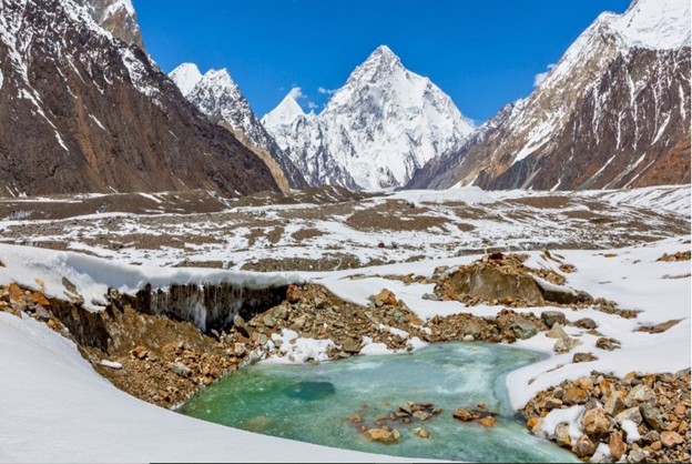
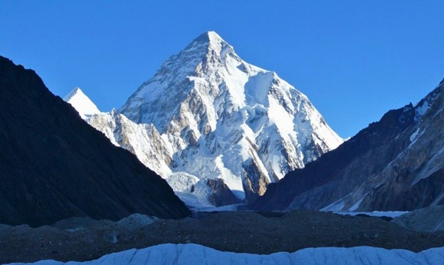
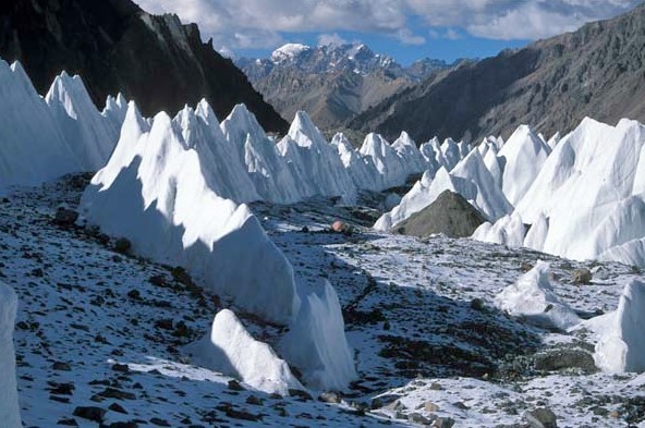
The famous Baltoro Glacier Trek then takes them deep into the Karakoram, past Paiju, Urdukas, and Concordia. The legendary amphitheater where the Baltoro, Godwin-Austen, and several other glaciers meet. - Base Camp: K2 Base Camp sits at around 5,150 meters (16,896 feet) on the Godwin-Austen Glacier.
This journey, lasting about two weeks on foot, is considered one of the world’s most spectacular treks.
At the Edge of Nations
K2’s position on the Pakistan-China border places it at the intersection of geopolitics and geography.
- Pakistan Side: Located within the Gilgit-Baltistan region, part of the wider Kashmir dispute.
- Chinese Side: The northern slopes lie in China’s Xinjiang Uyghur Autonomous Region.
- Access: Almost all ascents are made from the Pakistani side, partly because the Chinese side is more remote, icy, and even more technically challenging.
While politics have sometimes complicated climbing permits, K2 remains primarily approached through Pakistan.
The Heart of Baltistan
Most of the people living in the shadow of K2 are Balti. They are the descendants of Tibetan settlers, with a culture blending Tibetan, Central Asian, and Islamic influences.
- Language: Balti, a dialect of Tibetan, is widely spoken.
- Hospitality: Despite harsh living conditions, Baltis are renowned for warmth and resilience.
- Heritage: Villages like Askole, Hushe, and Khaplu preserve ancient stone houses, watchtowers, and Buddhist-era petroglyphs.
To see K2 is to glimpse the cultural mosaic of the Karakoram.
Landscapes & Surroundings
K2 doesn’t stand alone; it commands a realm of glaciers, rock towers, and other 8,000-meter peaks.
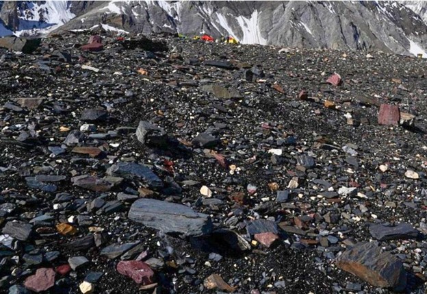
- Baltoro Glacier: One of the longest glaciers outside the polar regions, it leads trekkers toward K2.
- Concordia: The meeting point of glaciers, offering an awe-inspiring view of K2 and its neighbors.
- Neighboring Peaks: Broad Peak (8,051 m), Gasherbrum I & II, and Mitre Peak add grandeur to the skyline.
This terrain is rugged, glaciated, and hostile. Also known as the “Throne Room of the Mountain Gods“.
Why Its Location Adds to Its Challenge
K2 is notorious for being the hardest 8,000-meter peak.
- Steepness & Weather: Storms gather from the surrounding glaciers and Central Asian plateaus, making the weather highly unpredictable.
- Technical Difficulty: Unlike Everest’s southeast ridge, K2 offers no relatively “easy” route.
- Isolation: Evacuation is more complex than on Everest; helicopters rarely operate beyond Concordia.
Its position deep in the Karakoram magnifies these difficulties.
Beyond Borders: China’s Side of K2
Fewer know what lies on K2’s northern face.
- Chinese Side: Largely unclimbed, featuring steep glaciers and rock faces descending into Xinjiang’s Shaksgam Valley.
- Access: Rarely visited due to distance, harsh terrain, and complicated permits.
Although the northern approach is absolutely beautiful, it is still mostly the place of exploration.
Why Knowing K2’s Location Matters
K2 is more than a point on a map. The fact that it is located at the center of peoples and cultures gives it many meanings.
- It symbolizes nature’s raw power.
- It stands as a challenge to the human spirit.
- Its remoteness preserves it from mass tourism.
In a world growing smaller through technology, K2’s location keeps it partly hidden, partly mysterious.
Modern Developments & Tourism
- Infrastructure: Skardu now has a small airport handling direct flights from Islamabad.
- Roads: The Karakoram Highway connects Islamabad with Gilgit and Skardu.
- Tourism Growth: Trekking to K2 Base Camp (without summiting) has become more popular in recent decades.
Yet, it remains off the beaten track compared to Everest Base Camp or Annapurna Circuit.
K2 and Its Neighbors
Let’s visualize K2’s place among nearby landmarks:
- To the southeast: Gasherbrum massif.
- To the southwest: Broad Peak.
- To the north: Shaksgam Valley in Xinjiang.
- West: Valleys leading toward Gilgit and Skardu.
This neighborhood forms the densest cluster of the world’s tallest peaks.
The Ultimate Summary
So, where is Mount K2?
- In the Karakoram Range, part of the greater Himalayan system.
- On the Pakistan-China border: Gilgit-Baltistan (Pakistan) and Xinjiang (China).
- Surrounded by glaciers, remote valleys, and rugged peaks.
Its precise location makes it remote, dangerous, and deeply alluring.
Also, Learn about the 7 Highest Mountains in the world.
Why K2 Captures Our Imagination
K2’s name is stark, but its meaning runs deep. Its location:
- Places it among the world’s last true wildernesses.
- Keeps it largely free from commercialization.
- Connects cultures: Balti villages, Tibetan influences, and Uyghur valleys.
- Remains a proving ground for the world’s best climbers.
Knowing where K2 is isn’t just about coordinates. It is about understanding and gaining a knowledge a relam, where nature reigns supreme.
Mount K2 Base Camp Trek Itinerary
- Duration: 20 to 23 days
- Starting/Ending Point: Islamabad, Pakistan
- Highest Point: K2 Base Camp – approx. 5,150 meters (16,896 ft)
- Difficulty Level: Strenuous
- Best Time: Mid-June to late August
Note: For the base camp itinerary of world’s highest mountain Everest, visit “Everest Base Camp Trekking” package.
Day-by-Day Itinerary: K2 Base Camp Trek (Pakistan Side)
Day 1: Arrival in Islamabad (540 m)
- Arrive at Islamabad International Airport.
- Transfer to the Hotel and meet with the trek leader.
- Briefing at the Alpine Club of Pakistan.
- Overnight in a Hotel.
Day 2: Fly or Drive to Skardu (2,230 m)
- Option 1: Domestic flight to Skardu (weather permitting).
- Option 2: Drive along the Karakoram Highway (22-24 hrs, split into 2 days if needed).
- Explore Skardu in the evening.
- Overnight in the Hotel.
Day 3: Free Day in Skardu / Permit Clearance
- Rest and acclimatize.
- Final gear check, shopping, and local sightseeing.
- Obtain trekking permits and finalize porter arrangements.
- Overnight in the Hotel.
Day 4: Drive to Askole (3,040 m) – ~6-7 hours
- Travel by 4×4 jeep through Shigar Valley to Askole, the last village.
- Camp overnight near the Braldu River.
- First glimpse of the wild terrain ahead.
Day 5: Trek to Jhula (3,200 m) – ~5-6 hrs
- Begin trekking along the Braldul River.
- Cross rivers via suspension bridges and pass through barren landscapes.
- Camp at Jhula.
Day 6: Trek to Paiju (3,400 m) – ~6-7 hrs
- Walk through rocky terrain and side canyons.
- First full view of the Baltoro Glacier.
- Camp at Paiju beneath the Paiju Peak.
- Preparation for the glacier walk ahead.
Day 7: Acclimatization & Rest Day at Paiju
- Rest, acclimatize, and allow porters to bake fresh bread and prepare supplies.
- Optional short hikes nearby.
Day 8: Trek to Khoburtse (3,800 m) – ~6-7 hrs
- Start walking on Baltoro Glacier — rocky, icy terrain.
- Stunning views of Trango Towers and Cathedral Peaks.
- Camp on a glacial moraine near Khoburtse.
Day 9: Trek to Urdukas (4,050 m) – ~4-5 hrs
- Shorter but steeper section, with spectacular views.
- Camp above the glacier with views of Nameless Tower and Great Trango.
- Camp at Urdukas.
Day 10: Trek to Goro II (4,280 m) – ~6-7 hrs
- Continue along the icy Baltoro Glacier.
- Pass Masherbrum (7,821 m) and other massive peaks.
- Camp on the glacier at Goro II.
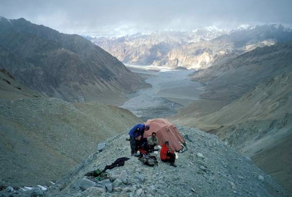
Day 11: Trek to Concordia (4,600 m) – ~5-6 hrs
- Arrive at Concordia, the “throne room of the mountain gods.”
- See K2, Broad Peak, Gasherbrum IV, Mitre Peak, and more.
- Camp with jaw-dropping 360° views.
Day 12: Trek to K2 Base Camp (5,150 m) & Back to Concordia – ~8-10 hrs
- Early start for a full-day round trip.
- Visit K2 Base Camp and admire the grandeur of the mountain.
- Optional stop at Gilkey Memorial (climbers’ memorial site).
- Return to Concordia for overnight.
Day 13: Trek to Ali Camp (5,000 m) – ~6-7 hrs (if crossing Gondogoro La)
- Optional route toward Gondogoro La Pass.
- Steep moraine trail; prepare for high-altitude pass crossing.
- Overnight at Ali Camp.
Day 14: Cross Gondogoro La (5,585 m) to Khuspang – ~10-12 hrs (weather-dependent)
- Steep climb with ropes and crampons.
- Incredible sunrise views of K2, Broad Peak, and the Gasherbrums.
- Descend carefully to Khuspang.
- Camp by the glacier.
Alternative for those not crossing the pass: Retrace via Baltoro Glacier.
Day 15: Trek to Shaicho (3,800 m) – ~6-7 hrs
- Walk along Hushe Valley, among alpine meadows and glacial rivers.
- The terrain is easier compared to the Baltoro side.
- Camp at Shaicho.
Day 16: Trek to Hushe (3,050 m) & Drive to Skardu – ~3-4 hrs trek + 6 hrs jeep
- Final short walk to Hushe Village, one of the highest settlements.
- Drive back to Skardu via Khaplu or Machulu.
- Hotel overnight.
Day 17: Fly or Drive to Islamabad
- Option 1: Morning flight to Islamabad.
- Option 2: Drive down the Karakoram Highway (1.5–2 days if flights are canceled).
- Hotel overnight.
Day 18: Buffer/Rest Day in Islamabad
- Debriefing at Alpine Club.
- Relaxation, shopping, or cultural exploration.
- Farewell dinner and certificate ceremony.
Day 19: Departure from Islamabad
- Transfer to Islamabad International Airport.
- End of services.
Optional Add-Ons:
- Visits Khaplu Fort, Shigar Fort, or visit Deosai Plains post trek.
- Before or after the trek Cultural visits can be made to Skardu or Hunza.
Trip Facts Summary:
| Category | Details |
| Altitude | Max: 5,585 m (Gondogoro La) |
| Duration | 19–23 Days |
| Trekking Days | 12–14 Days |
| Region | Baltistan, Karakoram Range |
| Route | Askole – Baltoro Glacier – Concordia – K2 Base Camp – (Optional Gondogoro La) – Hushe |
| Best Season | Mid-June to late August |
| Difficulty | Strenuous glacier trekking |
| Permits Required | Yes – Climbing & trekking permits |
| Guided? | Yes – Mandatory for foreigners |
Best Seasons for Mount K2 Base Camp Trek
Trekking to Mount K2 Base Camp is a high-altitude, glacial adventure in one of the most remote corners of the Karakoram Range. Due to the unfriendly local environment and unpredictable weather, the expedition/climb can be successful only with proper timing.
Here’s a detailed breakdown on best seasons to trek to K2 Base Camp, based on K2 temperature, weather, visibility, and accessibility:
Best Time to Go: Mid-June to Late August
Mid-June to Late August is the best trekking season to the K2 Base Camp. It provides the most favorable climatic conditions, panoramas, and easy to follow paths.
Mid-June to Early July
- Advantages:
- Fresh greenery in lower valleys like Skardu and Askole.
- Fewer crowds on the trail.
- A perfect photographer to get contrasts between fresh alpine flowers and snow capped peaks.
- Weather: Cold but stable; snow may still be melting at higher elevations.
- Trails: Glacier sections are still icy but passable.
- Note: Early in the season, there might be ice bridges or snow on the Gondogoro La Pass (if you plan to cross it).
Mid-July to Mid-August (Peak Season)
- Advantages:
- Most stable weather and most extended daylight hours.
- Warmest the year (relatively speaking).
- K2 summit expeditions are typically underway, Base Camp is lively.
- Concordia and K2 Base Camp offer the best chance of clear, unobstructed views.
- Weather: Day temperatures at Concordia can reach 10–12°C, but nights remain cold (below freezing).
- Trails: Clear and less frozen tracks.
- Crowds: There will be larger hiking groups and even expedition parties.
Late August
- Advantages:
- Still good visibility.
- Less-busy paths as trips start packing out.
- Photographic Golden light.
- Weather: Starting to cool down, with occasional snowfall at higher elevations.
- Risk: Increased chance of late-season storms or glacier crevasses forming as ice melts.
Seasons to Avoid
September to May (Off-Season)
- Winter (November–March):
- Deep snow, blocked trails, temperatures well below -20°C at high camps.
- All access roads and trekking routes are closed or extremely dangerous.
- No guide services or porters operate during this period.
- Spring (April–May):
- Lower valleys begin to thaw, but glaciers remain dangerous and unstable.
- Risk of avalanches and icefalls.
- Gondogoro La is often impassable due to heavy snow and crevasses.
Summary Table – Best Seasons for K2 Base Camp Trek
| Month | Trekking Conditions | Weather | Notes |
| June | Very good (after mid-June) | Cold but stable | Start of season, less crowded |
| July | Excellent | Stable, clear | Best time, busiest season |
| August | Very good | Cooling slightly | End of season, fewer crowds |
| Sept–May | Unsafe / Not recommended | Severe snow/cold | High risk, closed routes |
Tips for Choosing the Right Time
- If you want perfect views and vibrant base camps, choose mid-July to early August.
- If you prefer quieter trails and cooler trekking, go in late June or late August.
- Avoid the trek outside of June – August unless you’re on a professional winter expedition (extremely rare and high risk).
Tour Cost (2025-2026)
The cost of the Mount K2 Base Camp Trek depends on the type of service (standard vs luxury) , group size, route, and inclusions such as permits, transport, and logistics. Here’s a comprehensive and realistic price breakdown for an international trekker based on current rates in Pakistan for 2025 – 2026.
Average Cost Range
| Service Type | Duration | Cost Per Person (USD) |
| Budget Package | 18–20 days | $2500 – $3000 |
| Standard Package | 20–23 days | $3000 – $3,800 |
| Premium/Luxury Package | 20–23 days | $4500 – $5,500+ |
Prices are based on a group size of 6-12 pax. Private treks may cost more.
What’s Included in the Price
Standard Package Includes:
- Airport transfers (Pick up in Islamabad/ drop)
- Domestic flights (Islamabad ↔ Skardu, weather-permitting)
- Ground transport (4×4 Jeep Skardu – Askole or Hushe)
- All necessary trekking permits:
- Trekking Charges of Gilgit-Baltistan
- Baltoro & Concordia Special Area Permit
- Gondogoro La Crossing Fee (if applicable)
- Experienced local trekking guide
- Support staff:
- Cook, porters, and high-altitude assistants
- Accommodation:
- Hotels in Islamabad & Skardu (2–3 star or equivalent)
- Tented camps throughout the trek
- All meals during trekking days (breakfast, lunch, dinner)
- Group equipment (kitchen tents, sleeping tents, dining tents, tables, chairs)
- Medical kit and satellite communication device
- Luggage allowance for porters (usually 12–15 kg per client)
- Permit processing and documentation
Not Included in Standard Cost
- International airfare to/from Pakistan
- Travel insurance (with high-altitude coverage)
- Visa fees for Pakistan
- Additional Hotel nights due to flight delays (common in Skardu)
- Personal expenses (internet, phone, snacks, laundry)
- Tips for guides, porters, and staff (customary)
- Personal trekking gear (boots, sleeping bag, etc.)
- Helicopter evacuation (unless arranged separately)
Cost Variation Based on Group Size
| Group Size | Standard Package Price (USD) |
| Solo Trekker | $4,000 – $4,800 |
| 2–4 Trekkers | $3,500 – $4,000 |
| 5–8 Trekkers | $3,000 – $3,500 |
| 9+ Trekkers | $2,800 – $3,200 |
More people = shared cost of logistics and staff, hence lower per-person price.
Luxury Package May Include
- 4–5 star Hotel stays in Islamabad and Skardu
- Extra porters or personal porter service
- Hot shower tents, larger personal tents
- Private dining tents, better-quality meals/snacks
- Satellite phone usage allowance
- Helicopter flight from Concordia to Skardu (weather-dependent) – adds $3,500–$6,000 extra per flight.
Optional Add-Ons (Extra Charges)
| Add-On | Estimated Cost (USD) |
| Helicopter Rescue Insurance | $100 – $250 |
| Concordia to Skardu Helicopter | $3,500 – $6,000 (shared) |
| Gear rental (sleeping bag, etc.) | $100 – $200 |
| Tips for porters/guides (customary) | $100 – $200 total per trekker |
| Private trip supplement | $500 – $1,000+ |
Tips to Reduce Cost
- Join a group departure with 6+ trekkers.
- Use public/shared jeeps instead of private transport.
- Bring your gear to avoid rental fees.
- Book early to avoid seasonal surcharges and secure Skardu flight seats.
Final Thought on Tour Costs
The K2 Base Camp Trek is logistically intense and more expensive than treks like Everest Base Camp or Annapurna because:
- There are no lodges or teahouses. Everything must be carried and set up by the crew.
- Permits and logistics in Pakistan are stricter and less subsidized.
- Helicopter rescue is available but rare and expensive.
- Porters and staff must be paid higher due to the difficulty and altitude.
That said, the raw adventure, fewer crowds, and iconic mountain views make every dollar worth it.
Recommendation Read: Tea House Trek in Nepal
Also if you are wondering about Everest climbing cost, Explore our blog “How Much Does It Cost To Climb Mount Everest“.
Conclusion
Mount K2’s location is as awe-inspiring as the peak itself with remote, rugged, and reserved for the bold. It is located along the border between Pakistan ( Gilgit-Baltistan ) and China ( Xinjiang ) on the peaks of the Karakoram Range. Unlike many accessible peaks, K2 lies deep within glacier-carved valleys and towering rock spires, far removed from roads and civilization.Its remote location contributes to the fact that it is known as the “Savage Mountain” that is feared and respected by climbers all around the world.
Understanding where K2 is reveals more than a point on a map. It uncovers a region shaped by extreme geography and strong cultures. The trek to its base is a journey into one of Earth’s last wild places. K2’s harsh surroundings keep it largely untouched and fiercely natural. Its location in the Karakoram defines its identity and allure. Few have seen it, fewer have climbed it, but its magnetism draws all who learn about it. To know where K2 is? It is to see where the edge of the world still exists.
FAQs
Is K2 in India?
No, K2 is not in India. It sits on the border of Pakistan and China, within the Gilgit-Baltistan region of Pakistan and Xinjiang in China. The mountain lies deep in the Karakoram Range, far from India’s territory.
Is K2 part of the Himalayas?
No. K2 belongs to the Karakoram Range, which is separate from the main Himalayan range. While the Karakoram is part of the broader Himalayan mountain system, it stands apart, divided by the Indus River.
Can tourists see K2?
Yes, but you can’t just drive to it. Tourists can reach K2 Base Camp in Pakistan via a multi-day trek starting from Skardu, passing along the Baltoro Glacier to Concordia, where K2’s peak comes into view.
How far is K2 from Mount Everest?
K2 is roughly 1,450 kilometers (about 900 miles) northwest of Mount Everest. Both are in Asia but belong to different mountain ranges; Everest in the Himalayas and K2 in the Karakoram. For Everest Region treks Packages, click here.
Why is it called K2?
British surveyors named it during the Great Trigonometrical Survey of India in 1856. “K” stands for Karakoram, and “2” means it was the second peak they mapped in the range. The name stuck because no single local name was widely accepted.